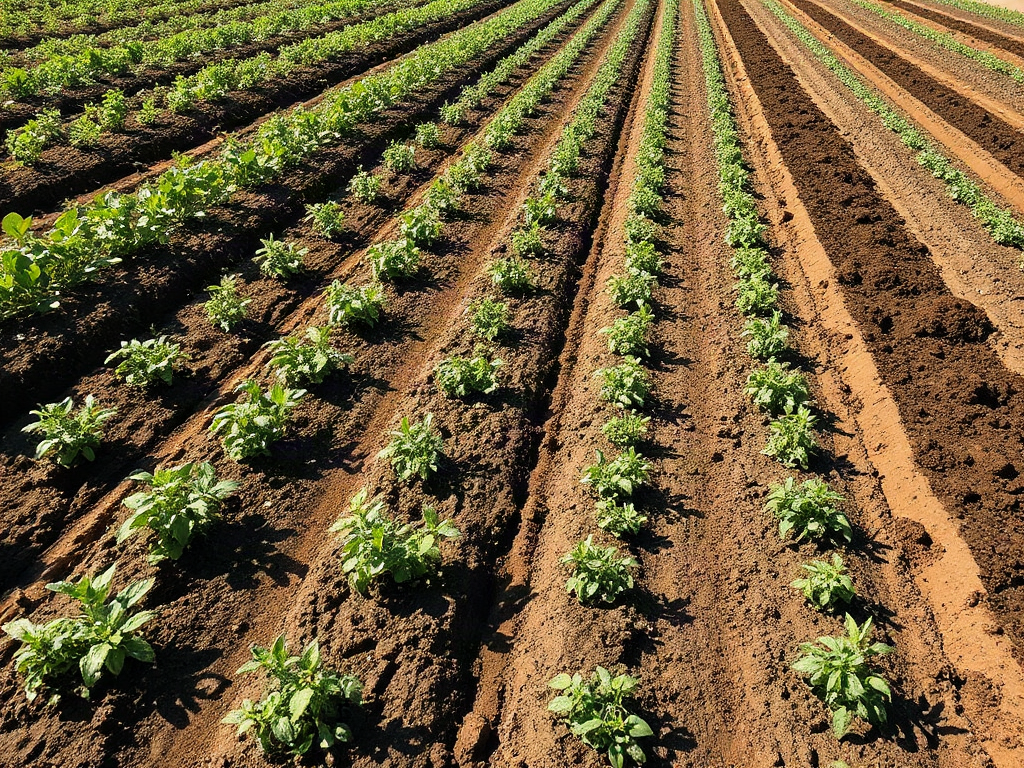
Strip farming protects erosion-prone homestead fields by arranging alternating bands of cultivated plants and dense cover across the direction of runoff. The protective strips slow surface water, trap displaced sediment, shorten uninterrupted slope length, and reduce the amount of bare ground exposed during heavy rain. Effective layouts follow the field contour, use cover that remains dense during vulnerable seasons, and provide safe outlets for concentrated water. Strip width must reflect slope, equipment, and erosion severity; strips that run downhill, leave gaps, or channel runoff along wheel tracks can worsen damage rather than control it.
How Strip Farming Interrupts Erosion
Water erosion gains force when rainfall can travel across a long, smooth stretch of exposed earth without meeting resistance. A cultivated strip offers relatively little protection after seedbed preparation, while an adjacent band of sod, close-growing grain, perennial forage, or thick cover creates roughness at ground level. Runoff slows as it enters that vegetation, allowing part of its sediment load to settle before the water continues downslope.
The method works through several connected mechanisms. Alternating vegetation shortens the effective length of the exposed slope, living roots hold aggregates together, and stems shield the surface from raindrop impact. Dense strips may also improve infiltration where the earth has not been compacted. None of these effects makes water disappear. During intense storms or on saturated ground, excess runoff still needs a stable route through or away from the field.
Contour strip cropping and simple rectangular strip farming are not interchangeable. On nearly uniform ground, straight bands placed across the general fall may perform adequately and simplify equipment passes. On rolling or irregular terrain, bands should bend with contour lines so cultivation does not create downhill channels. A strip that appears horizontal from the gate may still drop enough from one end to the other to collect fast-moving water.
Consider a vegetable plot occupying the upper part of a long incline. Leaving the whole plot tilled through spring creates a continuous launch path for runoff. Dividing it with permanent grass bands reduces that open distance, but only if the grass is thick, the bands remain unplowed, and traffic has not pressed a shallow channel through them. A narrow decorative border is not equivalent to a functioning buffer.
Strip farming for erosion-prone homestead fields is most useful where sheet erosion and small rills recur across manageable slopes. Deep gullies, unstable banks, seepage areas, or water arriving from roads and neighboring land may require diversions, grassed waterways, drainage corrections, or professional conservation planning in addition to strips. The common mistake is treating vegetation as a barrier that can safely dam concentrated flow; backed-up water often cuts around or through the weakest point.
Assessing the Field Before Marking Strips
A reliable layout begins with watching how the field handles water, not with choosing an arbitrary strip width. Walk the ground during a moderate rain when it is safe to do so, then return after the storm. Note where thin sheets become defined threads, where sediment fans appear, and where water enters from roofs, lanes, compacted animal areas, or higher ground. Those observations reveal flow paths that a dry-field inspection can miss.
Slope steepness matters, but slope length, surface condition, texture, and cover timing can matter just as much. A gentle yet long, freshly tilled incline can lose substantial topsoil because runoff has room to accelerate. A shorter slope under residue may be less vulnerable. Fine particles may seal at the surface, while sandy material can detach and move wherever flow becomes concentrated. Compacted headlands commonly shed water even when the neighboring beds absorb it.
Use a basic contour-finding method suited to the scale of the property. A laser level offers efficient readings, but a builder’s level, water level, or carefully constructed A-frame level can mark equal elevations on a modest field. Place visible flags along several contour points and stand back before committing. Smooth abrupt bends enough for safe mowing or cultivation without converting the line into a downhill grade.
A pre-layout check should cover four questions:
- Where does runoff enter and leave? Account for water originating beyond the planted area.
- Where is flow already concentrated? Mark rills, wheel tracks, swales, and terrace-like lips.
- What machinery must turn? Match workable widths to the mower, planter, tiller, or hand-bed system.
- When is the surface bare? Identify the rainy periods that coincide with cultivation or crop removal.
Do not till away existing rills and assume the problem has been measured. Their direction and spacing are valuable evidence. Photograph them, mark their heads, and identify whether they stop in vegetation or continue through it. If a gully is enlarging, if runoff crosses a building site, or if a failed outlet threatens a road or structure, seek help from a local soil and water conservation district or agricultural extension service before reshaping the site.
The assessment should produce a map of contours, concentrated-flow areas, access needs, and seasonally wet ground. That map is more valuable than a universal spacing formula because it ties the system to the actual source and movement of water.
Laying Out Practical Strips Across a Slope
Strip width should balance erosion control with workable field operations. Narrower cultivated bands reduce the distance runoff can travel over vulnerable earth, but excessively narrow bands create awkward turns, wasted edges, and repeated wheel traffic. Wider bands are easier to manage but expose a longer uninterrupted surface. The correct compromise depends on field shape, incline, crop cover, rainfall pattern, and the width of available equipment.
Begin at a stable reference contour near the upper part of the field rather than copying a fence that may run downhill. Establish the first protective band on that contour, then place cultivated and covered bands below it. Keep each band wide enough to complete normal passes without driving repeatedly on the same border. Where contours converge, use a permanent grassed wedge or adjust the cultivated area instead of forcing tight point rows that are difficult to seed and prone to bare patches.
For example, a homesteader using a walk-behind tiller can follow curved bands more closely than someone operating a compact tractor with a wide planter. The tractor operator may need broader, smoother curves and permanent turnaround areas. That operational concession is reasonable if the bands still cross the dominant flow direction. Making every line ruler-straight for convenient planting is not reasonable when the result sends furrows diagonally downhill.
Keep concentrated drainage separate from ordinary cropped strips. A shallow natural swale that carries runoff after storms should usually remain in dense, erosion-resistant vegetation rather than being planted in annual rows. Directing multiple strips toward an unstable ditch merely relocates sediment loss. A protected outlet must release water without creating a new scour point at the field edge.
Use this sequence when transferring the plan to the ground:
- Flag the contour and inspect it from both ends for unintended fall.
- Mark waterways, outlets, wet pockets, and no-till buffer areas first.
- Fit band widths to complete equipment passes and safe turning space.
- Seed protective vegetation before disturbing large cultivated areas when timing permits.
- Test the layout through rainfall and revise weak transitions before expanding it.
A frequent failure occurs where wheel tracks cross a protective band. Compressed tracks have lower infiltration and can become narrow flumes. Limit crossings, change their location when feasible, and repair depressions promptly. Similarly, avoid leaving a dead furrow along the uphill edge of grass; it may capture water and carry it laterally until it breaks through. Readers planning Strip farming for erosion-prone homestead fields should prioritize safe water movement over perfect symmetry.
Choosing Crops and Managing the Rotation
A protective strip succeeds only when its cover is dense during the field’s highest-risk period. Perennial grasses and grass-legume mixtures offer durable roots and dependable surface roughness, making them useful beside intensively cultivated vegetables or annual grains. Close-growing cereals and seasonal cover crops can serve in a rotating system, but their protection changes as they are seeded, harvested, or terminated.
Crop pairing should contrast vulnerable and protective phases. A band of widely spaced corn, squash, or another row crop leaves more exposed surface early in its growth than established sod or a thick small-grain stand. Alternating those conditions interrupts runoff. Alternating two freshly tilled row crops merely creates different plantings with similar erosion risk. Residue retained between rows can strengthen the cultivated band, while aggressive residue removal weakens it.
Permanent strips are easier for a beginner to evaluate because their position and function remain consistent. Rotating strips can distribute fertility demands and allow more of the field to produce annual crops over time, but rotation requires disciplined scheduling. When a protective band is converted to a tilled crop, another band must already provide sufficient cover. Converting all bands during the same season defeats the alternating pattern precisely when the surface is disturbed.
Suppose a field carries market vegetables in several bands with grass-clover alleys between them. The alleys can slow runoff and provide mowing material, but mowing them extremely short before storm season reduces surface roughness. Allowing them to become sparse from traffic is equally damaging. Conversely, unmanaged woody growth can interfere with cultivation and shade crop edges. Manage the cover for continuous ground contact, not maximum height.
Plant choice must also account for local climate and farm use. A species that establishes slowly may leave a vulnerable gap after seeding. Some vigorous plants can spread into cultivated beds, while forage intended for livestock must be compatible with the feeding plan. Local extension publications can help identify regionally adapted grasses, legumes, or cover crops without assuming that a mixture suited to another climate will persist.
The misleading assumption is that any green band provides erosion control. Patchy vegetation, bare wheel lanes, recently seeded cover, and dormant stands with little residue may offer far less resistance than their color suggests. Check the surface at ground level: stems and litter should interrupt flow across the full width, and roots should hold the upper layer together. A rotation calendar should explicitly mark establishment, termination, tillage, and peak-rain periods so protection is not lost through a scheduling oversight.
Checking Performance and Correcting Failures
Performance should be judged after runoff-producing weather, not by how orderly the bands look on a dry day. A working system leaves little fresh sediment on the lower edge of cultivated bands, keeps runoff spread rather than channelized, and maintains intact vegetation at crossings and outlets. Small deposits inside a protective strip show that it is trapping material, but growing sediment ridges may eventually redirect water and need careful correction.
Walk each boundary after major storms and compare it with dated photographs. Look for miniature deltas, exposed roots, crusted surfaces, fresh rills, flattened vegetation, and muddy discharge below the field. Probe suspicious wheel tracks to see whether they have become lower than the surrounding surface. Also inspect the uphill edge of every band; accumulated water there can travel sideways and break out where cover is thinnest.
Failure patterns often identify the needed response. Rills that run through cultivated bands usually indicate excessive uninterrupted slope length or rows drifting away from contour. A cut through one grass band points toward sparse cover, a crossing, or concentrated inflow. Water bypassing the end suggests the strip terminates poorly or has an unintended grade. Mud leaving through an otherwise stable outlet may mean erosion is occurring farther upslope.
Correct the source rather than repeatedly filling the visible scar. Options include narrowing vulnerable bands, widening or reseeding protective areas, shifting traffic, retaining more residue, adding a stable grassed waterway, or intercepting runoff that enters from a lane. Repairs made with loose soil alone are commonly washed out because they restore appearance without restoring resistance.
Strip systems also change as equipment, rotations, and weather exposure change. A compact tractor may create different compaction patterns than hand tools; a new tunnel or barn roof may discharge additional water; removal of an upper hedgerow may increase flow reaching the field. Review the arrangement whenever land use above or within the plot changes. Keep records of storm damage, repair locations, and crop cover so repeated trouble spots become visible.
Success means erosion is becoming shallower, less connected, and easier to contain—not that every drop of runoff is absorbed. If channels deepen despite adjustments, sediment reaches a stream or road, or the outlet remains unstable, strips have reached their practical limit. Combining Strip farming for erosion-prone homestead fields with professional conservation design may then be more economical than repeatedly rebuilding damaged beds.
Frequently Asked Questions
Should strip farming rows run across or down a slope?
Place the strips across the dominant slope and follow contour lines where practical. Downhill rows collect and accelerate runoff, which can create rills even when protective vegetation is nearby.
How wide should erosion-control strips be?
There is no dependable universal width. Use narrower cultivated bands as slope length or erosion risk increases, while keeping widths compatible with full equipment passes, turning space, and continuous protective cover.
Can cover crops replace permanent grass strips?
They can provide seasonal protection if establishment and termination leave no high-risk gap. Permanent grass is usually more predictable where runoff recurs or annual planting schedules routinely expose the surface.
Will strip farming repair an existing gully?
Not by itself. A gully carries concentrated flow and may require reshaping, stabilized vegetation, a designed waterway, or another engineered outlet before surrounding strips can protect the broader field.
How can I tell whether the strips are working?
Inspect after substantial rain. Effective bands keep runoff dispersed, reduce new rills, trap modest sediment without being buried, and deliver water to a stable outlet without fresh scour.
Conclusion
A useful strip system begins with a field-specific reading of runoff, contours, vulnerable surfaces, and safe outlets. Mark water paths before tilling, keep annual rows across the fall of the land, and maintain dense cover where flow is most likely to gather. Width matters less than preserving an alternating pattern that works with equipment without opening downhill channels.
Start on the most visibly eroding portion rather than redesigning every acre at once. Photograph existing rills, flag a contour, protect natural swales, and establish the first cover band before exposing more ground. Recheck boundaries, crossings, and outlets after meaningful rainfall. If damage keeps deepening or runoff arrives as concentrated flow from outside the plot, add appropriate water-control measures and consult local conservation assistance rather than expecting crop strips to perform as dams.